The state of Virginia is known for its wide array of wondrous landscapes. Hikers, sightseers, and outdoor enthusiasts come to see the famous Blue Ridge and Appalachian Mountains that stretch along the western border of the state.
A large portion of the mountainous lands and animal and plant species in Virginia are protected within the Shenandoah National Park and George Washington and Jefferson National Forest. Ample parking for trails and overlooks are available throughout and a multitude of campgrounds and visitor centers offer wildlife fanatics a place to roam and get in touch with nature.
SHARE THIS IMAGE ON YOUR SITE
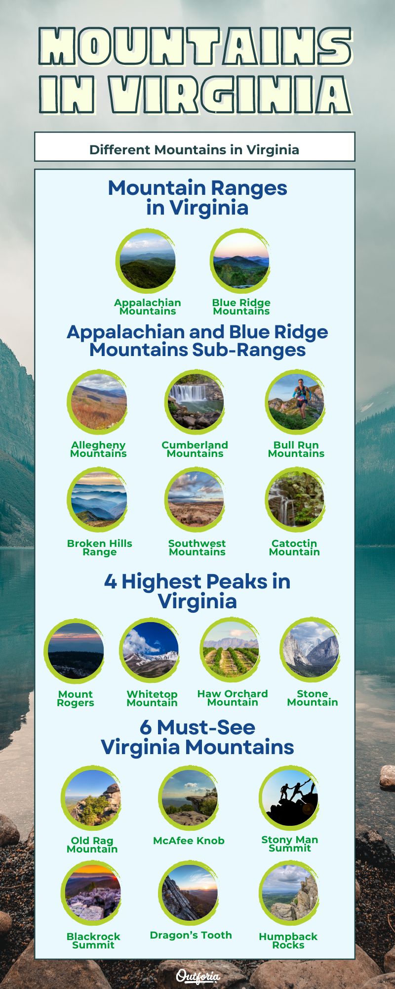
<a href="https://outforia.com/mountains-in-virginia/"><img style="width:100%;" src="https://outforia.com/wp-content/uploads/2022/12/mountains-in-virginia-infographics.jpg"></a><br>Mountains in Virginia <a href="https://outforia.com">Outforia</a>Two Mountain Ranges in Virginia
Virginia is home to a number of mountain ranges and ridges that stretch across the east coast of the United States. Much of the mountain ranges are interconnected by regions. The two parent mountain ranges in Virginia are the Appalachian Mountains and the Blue Ridge Mountains which consist of numerous sub-ranges.
1. Appalachian Mountains

View of the Southern Appalachians from the Appalachian Trail
The Appalachian Mountains is a long chain of ancient mountains that spreads across the eastern portion of the United States. Home to a wide variety of plant species and wildlife, the Appalachian Mountains have great biological diversity and scenic overviews of the valleys that are beneath them.
Appalachian Mountains Formation
The Appalachian Mountains formed 500 to 300 million years ago as a result of colliding continents. Erosion has caused the heights of the mountains to diminish significantly.
Volcanic and sedimentary rock layers are ancient remnants of history exposed in the Shenandoah National Park and the Blue Ridge Parkway.
Appalachian Mountains Location
The Appalachians are approximately 2,000 miles (3,218 km) long starting in Newfoundland and Labrador, Canada and the northeastern state of Maine and extend all the way down to central Alabama. These ancient mountains are older than the high-pointed Rockies in the west and are visited by avid hikers that roam the Appalachian Trail (A.T.).
The Appalachian Mountains travel down the western border of Virginia and have over 500 miles (804km) of the A.T. which is more than any other state.
Highest Point in Appalachian Mountains
Mount Mitchell is the highest point in the Appalachian Mountains, reaching an elevation of 6,683 ft (2,036 meters) in North Carolina. Mount Rogers is the highest point in Virginia with an elevation of 5,729 ft (1,746 meters) located in the George Washington and Jefferson National Forest in the southwestern region of the state.
Appalachian Trail
The Appalachian Trail traverses over 2,000 miles (3218 km) of the Appalachian Mountains starting in Georgia and leading all the way up to Maine. The Appalachian Trail Conservancy estimates that 3 million people hike portions of the A.T. each year. It takes approximately 5-7 months to hike the entire trail.
The trail was first proposed by a regional planner, Benton MacKaye in 1921 and completed over 10 years later in 1937. In 1968, the recreational footpath became a national scenic trail under federal protection thanks to the National Trail Systems Act that was signed into law by President Lyndon B. Johnson.
2. Blue Ridge Mountains

View of Skyline Drive from the top of Stony Man
The Blue Ridge Mountains, also known as the Blue Ridge province, start in Pennsylvania and stretch southwest down to Georgia. In Virginia, Shenandoah National Park covers 300 miles (483 kilometers) of the Blue Ridge and almost half of the land is a designated wilderness area.
Skyline Drive & Blue Ridge Parkway
The Blue Ridge Mountains have two major scenic routes for visitors to take. Skyline Drive is an extremely popular place for mountain lovers to travel. A multitude of parking areas are available along the road for scenic overlooks that give a bird’s eye view of towns and valleys below. Several trails are also located right off of parking areas along the road for easy access.
The Blue Ridge Parkway begins at US Hwy 250 and I-64 between Swannanoa and Afton, Virginia and connects to the Great Smoky Mountains of North Carolina.
Skyline Drive is a 105-mile (168 km) long road that travels along the crest of the Blue Ridge Mountains and takes approximately 3 hours to travel. There are 4 park entrances with the starting point beginning in Front Royal, Virginia at milepost 0 and the last entrance at Rockfish Gap Station (mile 104.6) which is also the northern entrance to the Blue Ridge Parkway.
The two other entrances are Thornton Gap at mile 31.5 near Luray by Rt. 211 and Swift Run Gap at mile 65.5 near Elkton by Rt. 33. The speed limit of Skyline Drive is 35 mph to ensure that travelers and critters that may be passing across the roads stay safe.
Blue Ridge Mountains Highest Points
The highest point of Skyline Drive is Hawksbill Mountain at mile 41.7 and is 3,680 ft (1121 meters) in elevation. At milepost 431 in North Carolina, Richland Balsam is the highest elevation on the Blue Ridge Parkway and reaches the height of 6,053 ft (1844 meters).
Blue Ridge Mountains Wildlife
Black bear in Shenandoah National Park amongst a field of wildflowers.
The Blue Ridge is home to diverse wildlife and it’s very common for visitors to encounter deer, black bears, wild turkey, and other woodland animals. The Blue Ridge province is a refuge for wildlife and helps preserve the habitats of over 200 species of animals.
Virginia Mountains: Appalachian and Blue Ridge Mountains Sub-Ranges
1. Allegheny Mountains

The Allegheny Mountains is a mountain range part of the Appalachian Mountains. The Alleghenies extend for hundreds of miles from the state of Pennsylvania down to the western portion of Virginia that hugs the West Virginia border line. The highest point of the mountain range is Spruce Knob at 4,863 ft (1,482 meters) located in West Virginia.
A portion of the Alleghenies is surrounded by the Geroge Washington and Jefferson National Forest, providing visitors with overlooks of beautiful foliage and trails to travel along. A majority of the Allegheny Mountains section in Virginia is home to deciduous hardwoods, accompanied by red spruce, eastern hemlock, and pine trees.
Trails in the Allegheny Mountains
1.1 Allegheny Mountain Trail (West Virginia)
- Type: Out & back
- Length: 13.1 miles (21 km)
- Difficulty: Hard
- Elevation gain: 3,832 ft (1167 meters)
- Access: Visitors from Virginia can travel on Rt. 33 through the scenic George Washington and Jefferson National Forest and cross into West Virginia. The trail is located off of Whites Run Road from Rt. 33.
- Features: Traverse along the trail with views of wildflowers and passings of Horse Rock and Little Mountain. The trail ends when it meets Seneca Creek Trail.
1.2 Locust Spring Loop
- Type: Loop
- Length: 6.4 miles (10.2 km)
- Difficulty: Moderate
- Elevation gain: 859 ft (261 meters)
- Access: Situated in the George Washington National Forest, the trail can be accessed from West Virginia Rt. 28 that runs along the western border of Virginia.
- Features: The trail is considered to be lightly trafficked and loops around the summit of Buck Knob.
2. Cumberland Mountains

Autumn at Cumberland Gap: Looking from Kentucky into Virginia
Located in the Appalachian Plateau region of Virginia, the Cumberland Mountains range is tucked in the far southwest corner of Lee County, Virginia. Similar to the Alleghenies, the majority of the Cumberland Mountains land is forested with approximately 95% of the forests being deciduous hardwoods.
The Cumberland Gap is a historic pass through the Cumberland Mountains that gave Native Americans and early pioneers a way to maneuver between the Appalachian Mountains. The Cumberland Mountains is also home to the Cumberland Gap National Historical Park with trail systems that pass through the thousands of acres of forest.
Trails in the Cumberland Gap National Historical Park
2.1 White Rocks
- Type: Out & back
- Length: 6 miles (9.6 km)
- Difficulty: Moderate
- Elevation gain: 1,761 ft (536 meters)
- Access: Off of Rt. 58 near Ewing, Virginia
- Features: Rocky trail that meanders in and out of Ewing Trail and steadily ascends for a slightly challenging hike that leads to a beautiful scenic overlook.
2.2 Gibson Gap
- Type: Loop
- Length: 9.7 miles
- Difficulty: Moderate
- Elevation gain: 2,280 ft
- Access: Trailhead begins off of Rt. 58 at Wilderness Road Campground in southern Virginia close to the northeastern border of Tennessee.
- Features: This hike is best for someone looking to take a nice moderate hike through a forest, but it does not offer any clear scenic overviews.
2.3 Chadwell Gap Trail
- Type: Out & back
- Length: 5 miles (8km)
- Difficulty: Moderate
- Elevation gain: 1,811 ft (694m)
- Access: Near Ewing, Virginia beginning off of Dry Branch Road from Rt. 58.
- Features: A rocky trail that can lead you to the historic Hensley Settlement with a break in the forest to have a scenic overview of the mountains.
3. Bull Run Mountains

The Bull Run Mountains range contains low-lying mountains in the Piedmont province of Virginia. The Piedmont region is known for being at the foothills of the Blue Ridge Mountains and is home to vast open lands and rolling hills. Easy and moderate trails can be found throughout this mountain range with the trails traveling up elevations of 500 to 600 ft. (152-182 m)
The highest point of the Bull Run Mountains range is Signal Mountain, which has an elevation of approximately 1,368 ft. (416 m)
Trails in Bull Run Mountains Range
3.1 Fern Hollow Loop
- Type: Loop
- Length: 3.4 miles (5.4km)
- Difficulty: Moderate
- Access: Off of Rt. 66 on Beverly Mill Drive in Broad Run, Virginia.
- Features: Myriad of historical structures and features along the trail that meanders through the woods with opportunities to see wildlife.
3.2 Dawson’s Trail
- Type: Out & back
- Length: 1.75 miles (2.8km)
- Difficulty: Easy to Moderate
- Features: Passes by historic cemeteries and over the natural quarry entrenchment through the woods. A great hike for a relaxing adventure that isn’t too strenuous.
3.3 Beech Ridge Loop
- Type: Loop
- Length: 1.35 miles including the trailhead (2.1km)
- Difficulty: Easy
- Features: A great place to spot white-tailed deer and native woodpeckers with minimal elevation changes for a peaceful hike.
All trails can be accessed off of Rt. 66 on Beverly Mill Drive in Broad Run, Virginia at the Bull Run Mountains Conservancy. A map for these trails can be found here.
4. Broken Hills Range

Located west of the Bull Run Mountains range is the Broken Hills range. The Broken Hills is a small collection of low-lying mountains in northern Fauquier County, Virginia. Here you will find Wildcat Mountain, along with a variety of plant life and animals such as the red and gray fox, deer, and occasionally black bears.
The Wildcat Mountain Loop was a 2.7 mile (4.3km) trail with 764 ft (232m) elevation gain, but unfortunately it is now closed to the public.
5. Southwest Mountains

Panoramic view from the Pine Mountain Summit in the Mount Rogers National Recreation Area.
Home to Mount Rogers, the highest peak in Virginia, Southwest Mountains are located at the southwestern foot of Virginia. The parent range of the Southwest Mountains is the Appalachian Mountains. This mountain range offers high scenic overlooks and long, strenuous trails to get your heart pumping.
Trails in Southwest Mountains Range
5.1 Helton and Elk Garden Trail Loop
- Type: Loop
- Length: 8.6 miles (13.8km)
- Difficulty: Moderate
- Elevation gain: 1,584 ft (482km)
- Access: Off of Rt. 58 on Whitetop Road where you will pass Bluff Mountain to reach the Elk Garden Trailhead near Troutdale, Virginia.
- Features: The path traverses through the forest where you will travel to the top of Balsam Mountain and get a side view of Mount Rogers and pass over Helton Creek.
5.2 Mount Rogers Trail
- Type: Out & back
- Length: 12.4 miles (19km)
- Difficulty: Hard
- Elevation gain: 2,427 ft (732m)
- Access: The trail can be accessed near Troutdale, Virginia where Laurel Valley and Fairwood Road meet close to the Grindstone Campground.
- Features: This strenuous hike will take you to the top of Mount Rogers. At the top you will be met with breathtaking views of other surrounding mountains such as Pine Mountain and Wilburn Ridge.
6. Catoctin Mountain

Located within the easternmost section of the Blue Ridge Mountains, the Catoctin Mountain range is 50 miles (80.5 kilometers) long starting in Emmitsburg, Maryland and travels down to Leesburg, Virginia. The mountain range offers scenic overlooks and summits and is part of the Catoctin Mountain Park. Camp David is a site in the Catoctin Mountains frequently visited by U.S. presidents.
Trails in Catoctin Mountain Range
6.1 The Ridge Top Trail
- Type: Loop
- Length: 1.3 miles (2km)
- Difficulty: Moderate
- Elevation gain: 232 ft (70m) (highest point is 640 ft (195m)
- Access: Ridge Top Trail is situated in Morven Park located in Leesburg, Virginia.
- Features: This trail traverses along the ridge of Catoctin and offers a steady hike of short elevation gain with opportunities to see wildlife and native flora and fauna. A picture of the trail map can be downloaded here.
6.2 Wolf Rock and Chimney Rock Trail (Maryland)
- Type: Loop
- Length: 3.4 miles (5.4km)
- Difficulty: Moderate
- Elevation gain: 823 ft (253m)
- Access: The trail can be accessed in Catoctin Mountain Park near Thurmont, Maryland off of Rt. 77 located close to the Catoctin Mountain Park Visitor Center.
- Features: This trail is a heavily trafficked loop but well worth the hike as it leads to wonderful views from the amazing Wolf Rock formation and Chimney Rock to overlook the Catoctin Mountain range.
Several maps for trails throughout the Catoctin Mountain Park in Maryland can be found here.
4 Highest Peaks in Virginia
1. Mount Rogers

Located between Damascus and Galax, Virginia sits the tallest mountain in the state standing at 5,729 ft. (1,746 meters) Mount Rogers is situated in the Mount Rogers National Recreation Area. The area consists of spruce-fir forests and open meadows.
Mount Rogers Recreation Area is the perfect place for adventurists to go hiking or set up camp as it offers many recreational activities for all to enjoy. Information on various trails and tips to help you plan your visit can be found here. Mount Rogers Trail is the most notable hike that leads to the summit for breathtaking sights of the Southwest Mountains.
2. Whitetop Mountain

Whitetop Mountain is the second highest summit in Virginia with an elevation of 5,525 ft (1,684 m) It can be found within the Grayson Highlands State Park in southwest Virginia off of Rt. 58. The highest point can be reached by car, but there are tons of hiking trails in the area.
Whitetop Mountain is a special place because at the top, viewers are able to see panoramic views of North Carolina, Tennessee, and Kentucky when the weather is clear.
3. Haw Orchard Mountain

Haw Orchard Mountain is located in Grayson County, Virginia and has an elevation of 5,080 ft. (1,548m). The peak, also called Big Pinnacle, is fairly easy to reach and the trailhead can be found within the Grayson Highlands State Park.
The Haw Orchard Mountain and Twin Pinnacles Loop is a 2.1 mile (3.3 km) trail that can be used to reach the top. It has a 547 ft (166 m) elevation gain and the difficulty is moderate. You can also reach the top from Massie Gap, which is a more challenging hike up steeper slopes.
4. Stone Mountain

At an elevation of 4,940 ft, (1505m) Stone Mountain takes 4th place out of the highest peaks in Virginia. The trailhead to Stone Mountain begins at the Cave Springs Recreation Area and traverses for 14.3 miles (23km) that features wondrous rock formations, cascades, and beautiful overlooks.
The closest town is Big Stone Gap in Lee County, Virginia. The entrance to Cave Springs is found on the right off of SR 621.
You may also like: How Long Does It Take To Climb Mount Everest? Everything You Need To Know
Six Must-See Virginia Mountains Scenic Views
1. Old Rag Mountain

Wintry scenic view from Old Rag Mountain
Old Rag Mountain is one of the most popular summits in Shenandoah National Park. Hikers are in for a workout with this hike, but it is well worth it to see the rewarding views at the top.
The summit is situated in the Shenandoah National Park between Elkton and Luray, Virginia to the east. The elevation of Old Rag is 3,238 ft (985m) and can be reached by taking the Old Rag Mountain Loop. The hike takes at least 5 hours and is long and strenuous with a 2,683 ft (817m) elevation gain.
Pets are not allowed on the Ridge, Saddle, Old Rag Access, and Ridge Access trails.
2. McAfee Knob

McAfee Knob is another summit that is extremely popular for hikers. The Appalachian Trail leads hikers to the summit and has wonderful panoramic views of the Catawba Valley and North Mountain. The heavily-trafficked trail is approximately 7.8 miles long and out and back.
The McAfee Knob trailhead can be found off of Catawba Valley Drive and is parallel to McAfee’s Knob Trail which leads to Catawba Mountain. This area has a multitude of footpaths for hikers to enjoy.
3. Stony Man Summit

The Stony Man summit can be reached from the Stony Man parking area at mile 41.7 (67.1 km) in Shenandoah National Park. The Appalachian Trail will lead you to the trail post.
For a short and easy 1.6 mile (2.5 km) round-trip hike, Stony Man Summit has beautiful views awaiting that look over the Shenandoah Valley and Massanutten Mountain.
Unfortunately if you are traveling with a furry friend, you won’t be able to enjoy this hike as pets are not allowed on this trail.
4. Blackrock Summit

A short and easy 1-mile (1.6km) circuit hike will take you to the Blackrock Summit. Despite the simple hike, the view of this summit is amazing with a fascinating geological formation of jumbled rocks that looks down on all that the Shenandoah Valley has to offer.
You can travel through the Shenandoah National Park to mile 84.4 where you will find the Blackrock parking area. From here, you will travel south on the Appalachian trail until you reach the trail post and make a right to get to the overlook.
5. Dragon’s Tooth

Dragon’s Tooth, Virginia
The Dragon’s Tooth is a popular rock formation that can be found when traveling up Cove Mountain with 360-degree views. The geological formation is a must-see if you ever find yourself around Roanoke, Virginia.
The Dragon’s Tooth Trailhead begins off of Catawba Valley Drive and meets up with the Appalachian Trail. It is 4.5 miles (7.2km) long and will take approximately 2 ½ to 3 hours to complete. The trail is out and back and deemed as challenging.
6. Humpback Rocks

Near Waynesboro and Charlottesville, Virginia, the Humpback Rocks is home to another grand geological outcrop. You can access the Humpback Rocks Loop Trailhead off of the Blue Ridge Parkway.
There are numerous trails surrounding the area, but the Humpback Rocks Loop is a moderate 3.8-mile (6.1km) hike that features wildflowers and wildlife along the way and breathtaking views from the rocks once you get to the end.
A map for Humpback Rocks hiking trails can be found here.
Shenandoah National Park

The Shenandoah National Park is a very popular tourist location for people who want to see the natural beauties of the Earth. The SNP experiences over 1 million visitors per year.
The 197,411 acres (79,889 ha) of park land are filled with scenic summits, a wide array of fauna and flora, cascading waterfalls, and wooded areas with Skyline Drive being the main road that goes through the park from top to bottom.
Members of the Civilian Conservation Corps helped build the roads, campgrounds, and human attractions of the SNP and it was officially established in 1935. The park is loaded with history from the early days of when Native Americans would travel through the mountains for hunting to the mountain pioneers that settled amongst the wooded forests.
You May Also Like: Check Out These List of US National Parks That You Should Know About with Photos, Infographics, Facts, and more!
George Washington and Jefferson National Forest

Map of the George Washington and Jefferson National Forest
The George Washington and Jefferson National Forest used to be two separate entities of their own until they were combined in 1995. The George Washington National Forest is located in west central Virginia and the Jefferson National Forest in southwest Virginia.
The forests are home to 40 different species of trees, 2,000 species of shrubs and herbaceous plants, and have a variety of wildlife with 200 species of birds, 60 species of mammals, and 78 species of amphibians and reptiles.
The two national forests make up approximately 1.8 million acres (728,434 ha) of protected lands with portions split between the states of Virginia, Kentucky, and West Virginia. The Appalachian Trail travels for 325 miles (523 km) throughout the forests.
Outstanding summits and hiking trails are abundant and have the ability to feed a nature enthusiast’s urge to get in touch with the wild.
You May Also Like: Learn What Are The Things You Can Do In Joshua Tree with Photos, Infographics, Facts, and more!
Appalachian Folklores and Mythology
The Appalachians have deep historical roots with mythical legends and folklore that have been passed down for generations and some of which still exist today. Ghost stories of the Appalachians easily evolved due to the isolation of communities and fearful encounters of creatures in the night.
Brown Mountain Lights
In the distance of the night skies on top of Brown Mountain in North Carolina, sightings of glowing orb-shaped lights have been reported. Called the “Brown Mountain Lights”, legends say these lights are the orbs of ghosts.
Some legends claim the lights are the ghost of a slave looking for his lost master. Other folklore tales claim that the lights are the orbs of lost warriors from battles on the mountain between the Cherokee and Catawba Native American tribes.
Anyone who wishes to observe the Brown Mountain Lights can do so at the Brown Mountain Light Overlook off the Blue Ridge Parkway at milepost 310, with the best times being between September and November.
Mothman

Mothman Statue in Point Pleasant, West Virginia
Residents from the town of Point Pleasant, West Virginia claimed to witness a tall winged figure that made the town go stir crazy in 1966. The creature is described as having a man-like figure with arms and legs and large moth-like wings standing at approximately 7 ft tall (2m).
The story of the mothman blew up with national press covering stories of the sightings within the small town and hundreds of sightings would follow after the first. Other strange events began shortly after, with locals reporting sightings of UFOs and mysterious men in black.